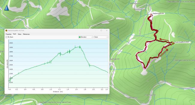
Maidenhead Mtn (W7W Summit 1930) is accessible with a 1.5 mile (800 ft vertical) hike up an abandoned Forest Service Road bed. The road bed is overgrown with trees that look around 8 years old. There is a trail that is established for about 50% of the way. The second half of the route has a significant amount of blowdown and really slows you.
The summit is forested with no views. I decided to try FM with a roll up J-pole and despite the trees had no problems getting into the Seattle area.
We parked at N47.36430° W123.33741°. The “trail head” is up a steep embankment behind a target shooting area. To get to the parking spot take NF-23, then NF-2350, then NF-2351.
The unfortunate thing about this activation was the high amount of trash. The parking area is strewn with garbage, and along the hike there was trash littering nearly the entire way. Maybe us SOTA folks can bring along some garbage bags and haul some bottles and cans out with each activation.
The route we took is shown below. We decided to try and go straight down the hillside on the way down. Doing that as a bushwhack on the way up would be pretty challenging, but it does shorten the one way hike to about .7 miles.


