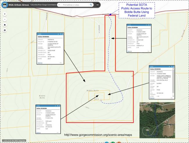
The summit of Biddle Butte (aka Mount Zion) is a drive-up radio site located on Corps of Engineers property. Public drive-up access is restricted due to private property and posted no trespassing signs. The private Mount Zion access road goes through the front yard of a residence with posted no trespassing signs at both ends of their property. Partway to the summit above the nearby residence is a locked gate. Radio site service personnel have an easement to travel to Biddle Butte.
Access to Biddle Butte is via Washington SR14 to Belle Center Road. Continue on Belle Center Road for 1.4 miles to Mt Pleasant Road, turn right and continue on Mt Pleasant Road for .4 miles to Strunk Road, turn right at the Y and continue on Strunk Road for another .4 miles and then turn right on the private Mt. Zion Road (from this point on requires access permission from the land owner). Continue on Mt. Zion Road past the residence and the locked gate for .8 miles to the summit.
There may be a way for public access --- Three sides of the Corps of Engineers property (0.69 acres) borders property owned by the descendants of the Biddle family (1.19 acres - see K7ATN’s 10/09/2012 Biddle Butte Blog for background history of the area). The south facing property line of the Corps of Engineers “surrounded property” borders with an adjacent Columbia River Gorge National Scenic Area property (28.07 acres). This CRGNSA property than borders with another CRGNSA property of 5.19 acres that can be directly accessed by Strunk Road, which is a public. On my way out I stopped at the CRGNSA property adjacent to Shrunk Road (~45.58526, -122.20665). There’s a barbed wire fence along the road, but no visible signs restricting access along the CRGNSA property. I also didn’t see any no trespassing signs beyond the normal fenced off shelter/tower leased areas while working at Biddle Butte.
Typically, there isn’t any travel restrictions for the public to access Federal Corps of Engineers or CRGNSA property that isn’t posted with a no trespassing or other limited access signs. So, the summit is one barbed wire fence and a serious roundabout bushwhacking hike away through the CRGNSA properties to the summit for the next activator to figure out. Let me know how it goes.


