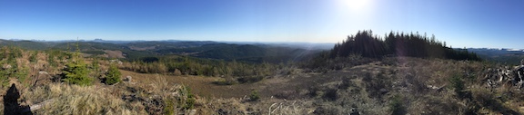
K7WXW's blog

K7WXW's picture

Trask Mountain, OR | December 2020

Summit: 
W7O/NC-003

Summary - An easy, if not terribly scenic drive to the trailhead and a short hike to the summit. Travel time to the trailhead was almost two hours.  VHF contacts were easy, as was APRS spotting. Trask is on public land but the route I followed goes through a Weyerhauser gate.

K7WXW's picture

Wildcat Mountain | November 2020

Summit: 
W7O/WV-046

Short Version - Wildcat Mountain is only an hour from Portland. You can drive to the trailhead and the two-ish mile hike along a well-maintained, if not well-marked, trail gets you to a small clearing on a summit with wire-ready trees. APRS messaging and 2M FM contacts are both easy and it is a good location for working HF. You are unlikely to be alone, as the Douglas and 781 trails are quite popular; if you like solitude, get there early. And be prepared for snow, even in early November.

K7WXW's picture

Skyline Ridge (Peak 761), OR | November 2020

Summit: 
W7O/WV-138

This is an urban park activation about thirty minutes from downtown Portland. No GPS device needed as Google maps provides good driving directions. Though you can pull off a 2M sidelwalk activation near the summit (which is on private property), a more pleasant place to operate from is Skyline Ridge Park (45.3905, -122.6634), about a half mile south. RF noise levels are high, so while a nice spot for an activation, don't expect big things on the HF bands.

K7WXW's picture

Peak 3534, OR | October 2020

Summit: 
W7O/NC-065

TL;DR - Peak 3534 is a twenty to thirty minute drive from South Saddle Mountain (W7O/NC-002) over logging roads. You pass South Saddle to get to 3534 so a two summit, four point day is easy. 4WD, good directions, and GPS are really handy. Once you park, the short hike up is steep but no worries, there's a longer, gentler path, too. The summit has no views, a small open space, trees, good APRS signals, and is RF quiet. Not a summit for hanging out nor the best place for HF antennas but easy to activate with 2M FM.

K7WXW's picture

South Saddle Mountain, OR | October 2020

Summit: 
W7O/NC-002

TL; DR - There are at least six Saddle Mountains in W7O and W7W, this is the one close to peak 3534. The drive to the parking area is easily done in a 4WD vehicle but is a bit confusing, so have a good map and GPS. From the parking lot to the summit, the walk is easy. I had no RFI issues, good two-way APRS, and a comfortable spot (in the sun) to sit. Below the commercial communications site, you will find trees for wires and a broad view to the east.

K7WXW's picture

Giveout Mountain, OR | October 2020

Summit: 
W7O/NC-023

Giveout Mountain's summit can be reached by car or truck on generally good logging roads. Portions of the drive up are steep and narrow; I recommend 4WD. There is recent evidence of a shooting range on the summit. During my visit several groups scouted the area and there were at least a dozen such ranges set up in the vicinity. I imagine that arriving in the late morning on a weekend day may lead to disappointment.

K7WXW's picture

Bunker Hill, OR | September 2020

Summit: 
W7O/NC-038

Bunker Hill is an unremarkable summit that can be reached, cautiously, with a 4WD vehicle. After you leave the highway, the way up has a number of branch points; GPS or a map will be handy.  When you get to the yellow gate, take down your antennas and be carefree about your paint getting scratched, otherwise, park here and hike up. It is roughly a 300' climb over half a mile. 

Here is a gaiagps map with driving and hiking information: W7O/NC-038 route.  

K7WXW's picture

Larch Mountain WA | September 2020

Summit: 
W7W/LC-103

TL;DR version - A nice four pointer and a good place to do a leisurely activation. Enough of a hike to feel like the one worked for the summit. Good APRS coverage, okay ATT data coverage. QRM on small portions of the CW frequencies (40/30/20M). Get there early or risk not finding a place to park and don't forget your WA Discover Pass.

K7WXW's picture

Sheridan Peak, OR | July 2020

Summit: 
W7O/NC-009

NC-009, Sheridan Peak, is a good first-time activation destination.  It is an easy half-mile hike (about 300' climb) from the parking lot to the summit, which is broad and flat; lots of good spots to set up.  The summit is wooded and shady with a fair amount of old growth, so there are no views. Cell data service is spotty. I managed to spot myself once with SOTA GOAT though I tried four or five times. Two way APRS coverage was excellent and I spotted myself on aprs using a VX8DR.